Nautical Navigation Tools: A Comprehensive Guide
From ancient seafarers navigating by the stars to modern sailors utilizing high-tech GPS systems, the art of nautical navigation has evolved significantly over centuries. The tools used for navigating the vast oceans have transformed from rudimentary devices to sophisticated instruments that ensure safe and accurate voyages. In this article, we delve deep into the world of nautical navigation tools, exploring their history, functions, and significance in maritime activities.
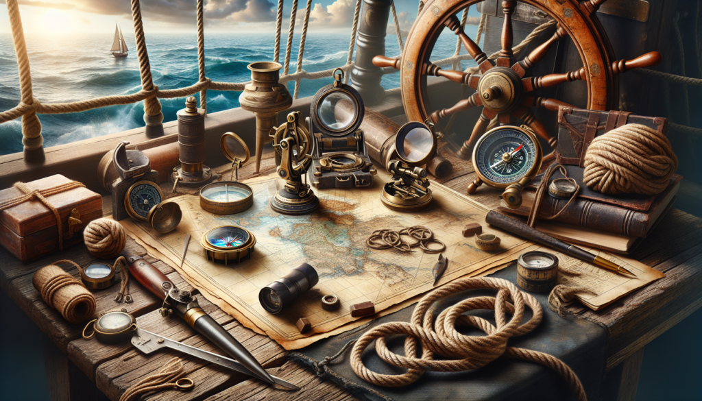
1. The Sextant: A Timeless Navigation Instrument
One of the most iconic nautical navigation tools is the sextant, a device that has been used by sailors for centuries to determine their position at sea. The sextant works by measuring the angle between a celestial body, typically the sun or a star, and the horizon. By using this angle and the known position of the celestial body, sailors can calculate their latitude and longitude.
Although the sextant may seem outdated in the age of GPS, it remains a crucial tool for sailors, especially in situations where electronic devices may fail. The skill of using a sextant requires precision and practice, making it a valuable asset for navigators seeking to hone their craft.
2. The Compass: A Reliable Guide Across the Seas
Arguably the most fundamental of all nautical navigation tools, the compass has been a staple on ships for centuries. The magnetic compass functions by aligning itself with the Earth’s magnetic field, indicating the direction of the ship’s heading. This simple yet effective tool has been instrumental in guiding sailors through uncharted waters and adverse weather conditions.
While modern ships rely on electronic gyrocompasses for navigation, traditional magnetic compasses are still widely used as backup systems. The simplicity and reliability of the compass make it an indispensable tool for mariners of all levels of experience.
3. Charts and Maps: Navigational Aids for Precision Navigation
Charts and maps have long been essential tools for sailors, providing detailed information about coastlines, depths, currents, and other navigational hazards. Nautical charts, in particular, are designed specifically for maritime use, featuring symbols and annotations that aid in safe passage through waterways.
With the advent of digital mapping technologies, electronic charts have become increasingly popular among sailors. These interactive maps offer real-time updates and can be customized to display various layers of information, enhancing situational awareness and navigation accuracy.
4. GPS Systems: Revolutionizing Maritime Navigation
The Global Positioning System (GPS) has revolutionized maritime navigation by providing accurate and real-time positioning information to ships anywhere on the globe. GPS receivers use signals from a network of satellites to determine a vessel’s exact location, speed, and direction.
GPS systems have significantly improved the safety and efficiency of maritime operations, allowing ships to navigate with pinpoint accuracy and avoid potential hazards. From commercial vessels to recreational boats, GPS has become an indispensable tool for modern sailors navigating the world’s oceans.
5. Radar and Sonar: Tools for Navigating in Low Visibility
Radar and sonar are essential tools for navigating in low visibility conditions, such as fog or darkness. Radar uses radio waves to detect objects in the vicinity of the ship, providing information about their distance and bearing. Sonar, on the other hand, uses sound waves to map the seafloor and detect underwater obstacles.
These technologies are crucial for avoiding collisions with other vessels, tracking weather patterns, and conducting search and rescue operations. Radar and sonar systems have become standard equipment on most ships, ensuring safe navigation even in challenging environments.
6. Celestial Navigation: Navigating by the Stars
Before the advent of modern electronic navigation tools, sailors relied on celestial navigation to determine their position at sea. By observing the positions of stars, planets, and other celestial bodies, navigators could calculate their latitude and longitude with remarkable accuracy.
While celestial navigation is no longer the primary method of maritime navigation, it remains a valuable skill for sailors seeking to navigate without relying on electronic devices. The ability to interpret the night sky and calculate positions using celestial bodies is a testament to the art and science of traditional navigation.
7. Conclusion: Navigating the Seas with Precision and Skill
In conclusion, nautical navigation tools play a vital role in ensuring the safety, efficiency, and accuracy of maritime operations. From the timeless sextant to the high-tech GPS systems of today, these instruments have guided sailors across the seas for centuries, allowing them to navigate with precision and skill.
Whether navigating by the stars or relying on electronic devices, mariners must possess a deep understanding of nautical navigation tools and their functions. By mastering these tools and techniques, sailors can embark on voyages with confidence, knowing that they have the means to navigate the oceans with expertise and precision.
So, the next time you gaze out at the vast expanse of the sea, take a moment to appreciate the ingenuity and sophistication of the nautical navigation tools that have guided sailors through the ages.